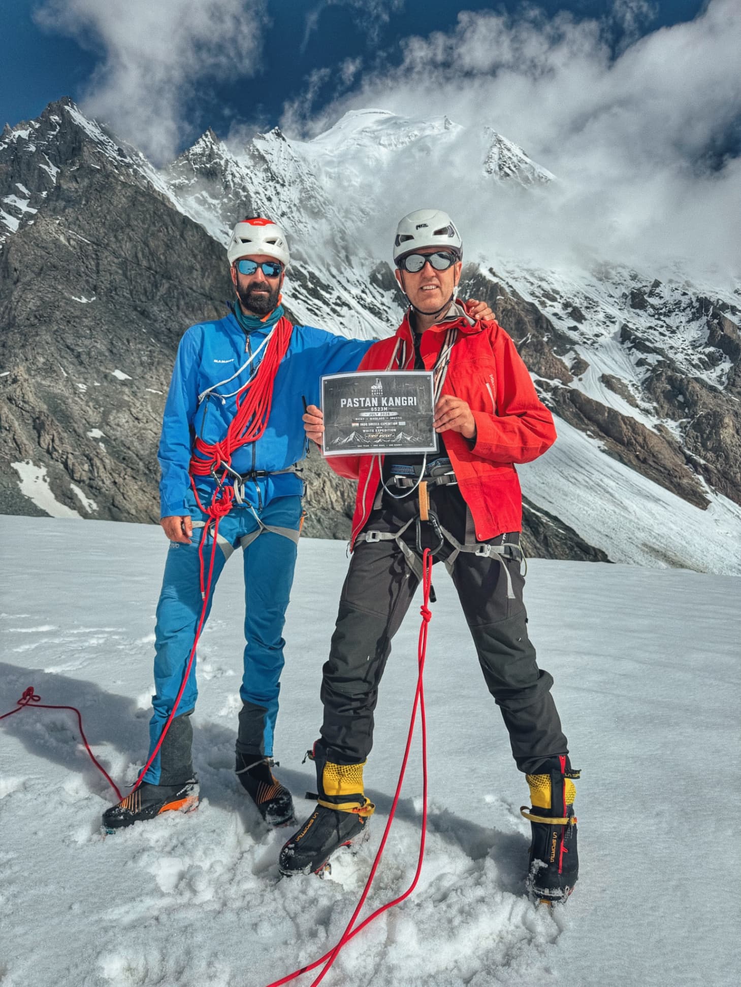
Rockfall , East Karkorm Ladakh, India
Rockfall , East Karkorm
Ladakh, India
5000 ft
5000 ft
12.00 miles
8 hours
July 20, 2026
August 28, 2026
Description
Pastan Kangri (6523 m), East Karakoram, India An Indo–Greek Reconnaissance of the Pastan Glacier and the Unnamed Col (5467 m) Rahul Thakur (Ricky Mountaineer) Expedition Leader, White Expedition Team Members: Rahul Thakur (India), Nikolai (Greece), Orestis (Greece) Liaison Officer: Sahil (Indian Air Force) Abstract Pastan Kangri (6523 m) is one of the least documented peaks in the East Karakoram of Ladakh, India. Situated within a remote border region requiring special governmental permission,
Trip Type
Mountaineering
Pastan Kangri East karakoram
Pastan Kangri (6523 m), East Karakoram, India
An Indo–Greek Reconnaissance of the Pastan Glacier and the Unnamed Col (5467 m)
Rahul Thakur (Ricky Mountaineer)Expedition Leader, White ExpeditionTeam Members: Rahul Thakur (India), Nikolai (Greece), Orestis (Greece)Liaison Officer: Sahil (Indian Air Force)
Abstract
Pastan Kangri (6523 m) is one of the least documented peaks in the East Karakoram of Ladakh, India. Situated within a remote border region requiring special governmental permission, the mountain has received very little modern mountaineering attention. Reliable information concerning its approach, glacier conditions and possible climbing routes remains extremely limited.In July 2026, White Expedition organised an Indo–Greek exploratory expedition with the objective of assessing the mountain, documenting access to the Pastan Glacier and evaluating potential routes on the South-East Face. Following mandatory acclimatisation in Leh, including a successful ascent of UT Kangri (6040 m), the expedition entered the Waris Valley after weather-related delays caused by unusually heavy monsoon rainfall.
www.whiteexpeditions.com
The team established an advanced camp on an unnamed col at 5,467 m after negotiating unstable moraine, steep scree slopes and glaciated terrain. Detailed reconnaissance of the upper glacier and the South-East Face revealed persistent rockfall, concealed crevasses and repeated wet-snow avalanches affecting all practical lines of ascent. After careful assessment, the expedition unanimously decided to terminate the climb owing to unacceptable objective hazards.Although the summit remained unattained, the expedition successfully documented the approach to the Pastan Glacier, recorded GPS data to the unnamed col and gathered observations that may assist future mountaineering expeditions to this remote part of the Indian Karakoram.
Introduction
The East Karakoram remains among the most isolated mountain regions of the Indian Himalaya. Unlike the well-known peaks of Ladakh and Zanskar, many summits in this area continue to receive little exploration because of restricted access, complex logistics and challenging terrain. As a result, reliable modern mountaineering information is scarce.Pastan Kangri (6523 m) lies within one of these remote valleys. Apart from its mapped position, little has been published regarding the approach, glacier characteristics or feasible climbing routes. This lack of documented information formed the primary motivation behind the expedition.Rather than focusing solely on a summit attempt, the expedition was designed as a reconnaissance. The principal objectives were to establish access through the Waris Valley, assess the condition of the Pastan Glacier, identify potential camp locations and evaluate whether the South-East Face offered a safe line of ascent under prevailing conditions.
Expedition Preparation
The international team assembled in India during July 2026. The Greek members, Nikolai and Orestis, arrived on 12 July before travelling to New Delhi, where the mandatory expedition briefing and documentation were completed at the Indian Mountaineering Foundation (IMF).Following the completion of administrative formalities, the team travelled to Leh to undertake acclimatisation before entering the restricted border region. As part of this programme, the team successfully climbed UT Kangri (6040 m). The ascent provided effective altitude adaptation while also allowing climbing equipment, communication systems and team procedures to be tested before the main expedition.This acclimatisation phase proved particularly valuable given the objective of establishing an advanced camp above 5,400 m in a remote valley where immediate rescue or evacuation would not be readily available.
Weather Delays and Journey to Nubra
The expedition originally intended to leave Leh on 22 July 2026. However, widespread rainfall affected Ladakh during the preceding days, resulting in landslides that temporarily closed the Leh–Nubra highway. Movement was delayed until road-clearing operations allowed traffic to resume during the afternoon.Persistent rain continued throughout the journey, slowing progress considerably. The expedition eventually reached Nubra Valley at approximately 1630 hrs on 23 July.Because the team arrived after government offices had closed, mandatory permit verification with the local administration could not be completed that day. The expedition therefore established camp and postponed further movement until the following morning.On 24 July, weather conditions remained poor. Together with Liaison Officer Sahil, the team visited the District Administration office, where officials advised against entering the upper valley until conditions improved. Later the same day, the Indian Army requested an inspection of the expedition's satellite communication equipment before granting permission to proceed into the restricted area. The satellite phone was tested successfully, but the recommendation from both civil and military authorities remained unchanged: movement towards the mountain should wait until the weather stabilised.
Arrival at Waris
Improving weather on 25 July finally allowed the expedition to continue towards Waris, a small settlement situated at approximately 4,100 metres.Unlike many trekking villages in Ladakh, Waris offers no commercial accommodation or tourism facilities. Through local contacts, the expedition was hosted by a village family whose hospitality and logistical assistance proved invaluable.Four local porters were engaged to transport climbing equipment towards the upper valley. Conversations with local residents suggested that the route beyond the village was rarely travelled and that the porters themselves had not previously visited the upper basin leading towards the Pastan Glacier.The remainder of the day was devoted to sorting loads, checking technical equipment and making initial visual observations of the mountain from viewpoints above the village. Considerable snow remained visible across the upper slopes, raising early concerns regarding conditions on the South-East Face.
Pastan Kangri Expedition Report
Part 2 – Approach, Camp Establishment and Route Reconnaissance
Approach to the Unnamed Col
The expedition departed Waris at approximately 0600 hrs on 26 July 2026 under light rain. Within the first hour the weather gradually improved, allowing clear views of the upper valley. From the roadhead at approximately 4,100 m, the route followed a long glacial valley dominated by unstable moraine composed of loose granite boulders, scree and glacial debris.Progress was considerably slower than expected. Every step across the moraine demanded careful foot placement as rocks shifted beneath heavy expedition loads. The final 200 vertical metres below the unnamed col consisted of loose scree with slopes approaching 50°, making it the most physically demanding section of the approach.After nearly seven hours of climbing, the expedition reached the unnamed col at 5,467 m. The four local porters arrived approximately one hour later, completing what was believed to be their first journey into the upper Pastan Valley.
Camp Establishment
A four-person expedition tent was established on a stable rocky platform close to the crest of the unnamed col. The position provided direct access to the Pastan Glacier while also offering an excellent viewpoint from which to assess the South-East Face of Pastan Kangri.Water was obtained by melting snow and meals consisted primarily of ready-to-eat expedition food. Once equipment had been unloaded, the porters returned to Waris, leaving the climbing team alone on the mountain.During the evening the team carried out a visual assessment of the intended climbing route. Initial observations immediately raised concerns, as continuous rockfall could be seen descending through several gullies on the planned line of ascent.
Reconnaissance of the Pastan Glacier
The team departed camp at approximately 0600 hrs on 27 July under clear skies. Although overnight cooling had improved snow stability, rockfall remained active on the original route.To investigate alternative options, the team descended roughly 200 m on the north-east side of the col before traversing onto the upper Pastan Glacier. The glacier, approximately 2 km in length, appeared completely untouched. No previous campsites, cairns, fixed ropes or other signs of mountaineering activity were observed.Fresh snowfall of approximately 30 cm covered the glacier, concealing several crevasses beneath weak snow bridges. Rope travel was adopted immediately. All members wore harnesses, crampons and helmets, and carried ice axes throughout the reconnaissance. Three concealed crevasses were identified, confirming that glacier travel required continuous caution.
Assessment of the South-East Face
After approximately one hour of exploration, the expedition gained a clear view of the South-East Face of Pastan Kangri. Several snow slopes approached 60°, while isolated mixed sections appeared considerably steeper, approaching 80°.As temperatures increased towards midday, meltwater destabilised the fresh snowpack and repeated wet-snow avalanches were observed. Continuous rockfall was also recorded, particularly during the afternoon between approximately 1400 and 1800 hrs. Every practical line of ascent crossed beneath active avalanche paths or unstable rock gullies.Despite carrying the necessary technical equipment, including ropes, harnesses, crampons, helmets and ice axes, the hazards encountered were objective in nature and could not be mitigated by climbing technique alone. No safe route towards the summit could be identified under the prevailing conditions.
Decision at the Col
Following several hours of observation from different positions on the glacier and the unnamed col, the team reviewed every possible option. The evidence was consistent: objective hazards exceeded an acceptable level for a safe ascent.The expedition therefore unanimously decided to abandon the summit attempt. Although disappointing, the decision reflected sound mountaineering judgement and the principle that a safe return always takes precedence over reaching the summit. The remainder of the day was spent preparing for the descent to Waris.
Pastan Kangri Expedition Report
Part 3 – Discussion, Conclusions and Supporting Information
Mountain Observations
Although the summit remained unclimbed, the expedition collected important information that may benefit future parties. The approach from Waris to the unnamed col consisted primarily of unstable moraine with a final 200 m section of loose scree approaching 50°. The unnamed col at 5,467 m provided a practical campsite and an excellent observation point over the upper glacier and the South-East Face.The Pastan Glacier, approximately 2 km in length, appeared undisturbed. No cairns, campsites, fixed ropes or other evidence of previous mountaineering activity were observed during the reconnaissance. Around 30 cm of recent snow concealed several crevasses, three of which were identified during rope travel across the glacier.The South-East Face was heavily loaded with seasonal snow. Afternoon warming triggered repeated wet-snow avalanches and continuous rockfall, particularly between 1400 and 1800 hrs. Under these conditions, no safe line of ascent could be identified.
Discussion
Reconnaissance expeditions play an important role in Himalayan exploration by documenting terrain, mountain conditions and potential routes for future teams. While the summit of Pastan Kangri was not reached, the objectives of documenting the approach, assessing glacier conditions and evaluating the South-East Face were successfully achieved.The observations suggest that the timing of any future attempt will be critical. A period of colder, more stable weather with reduced seasonal snow accumulation may significantly reduce avalanche activity and improve the chances of identifying a viable climbing route.
Lessons for Future Expeditions
Future teams should allow sufficient time for weather delays, particularly during the monsoon period. Rope travel is strongly recommended on the Pastan Glacier because fresh snow may conceal crevasses beneath weak snow bridges. The unnamed col at 5,467 m offers a suitable advanced camp, while continuous monitoring of rockfall and avalanche activity is essential before committing to the South-East Face.The expedition also reinforced an important principle of mountaineering: objective hazards must always take precedence over summit ambition. Responsible decision-making remains the foundation of safe exploration.
Conclusion
The July 2026 Indo–Greek expedition organised by White Expedition contributed valuable information about one of the least documented mountains in the East Karakoram. Although objective hazards prevented a summit attempt, the expedition successfully established access to the upper basin, documented the approach to the Pastan Glacier, recorded GPS data to the unnamed col at 5,467 m and completed a detailed reconnaissance of the South-East Face.The information collected during this expedition provides a useful reference for future mountaineering teams and adds to the limited body of knowledge concerning this remote region of the Indian Karakoram.
Expedition Data
Acknowledgements
The expedition gratefully acknowledges the Indian Mountaineering Foundation (IMF) for expedition coordination, the Indian Army and local civil authorities for their support in the restricted border region, the residents of Waris Village for their hospitality, and the four local porters whose efforts made the reconnaissance possible.
Suggested Figure Captions
Figure 1. Expedition team during the approach to the upper valley.Figure 2. Moraine approach towards the unnamed col.Figure 3. Expedition camp at 5,467 m.Figure 4. The untouched Pastan Glacier.Figure 5. South-East Face of Pastan Kangri showing avalanche gullies.Figure 6. Rope travel across the glacier.Figure 7. GPS record confirming the highest point reached.Figure 8. Descent from the unnamed col towards Waris.
Item
Details
Peak
Pastan Kangri
Elevation
6523 m
Range
East Karakoram
Coordinates
34°54'31.86"N, 77°08'40.91"E
Roadhead
Waris (4100 m)
Highest Point Reached
Unnamed Col (5467 m)
Glacier
Pastan Glacier (~2 km)
Team
Rahul Thakur, Nikolai, Orestis
Liaison Officer
Sahil
Expedition Dates
23–28 July 2026
www.whiteexpeditions.com
Click to interact with the map